Pages

Sunday, 9 February 2014

Photo of the Month: January 2014

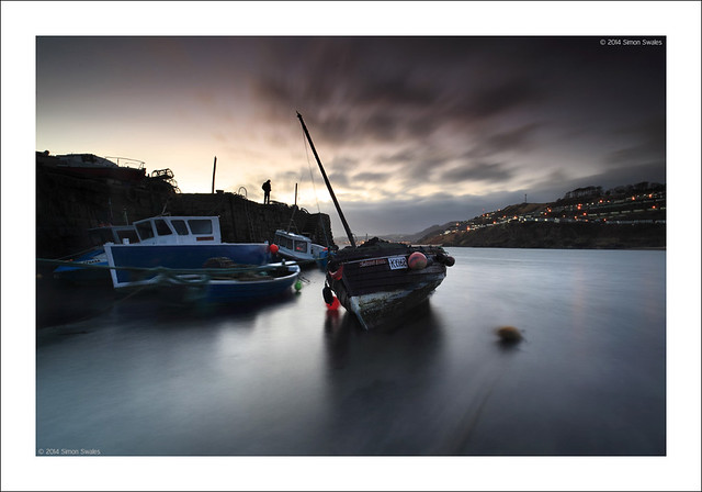
The Watcher
The Watcher, Pettycur Harbour, Fife


8th January 2014, Pettycur Harbour, Fife.

Pettycur, on a headland south of Kinghorn, has a harbour for both pleasure craft and small fishing boats.  It has a single stone pier which provides a haven to moor boats in the sandy and tidal Pettycur Bay.  The pier is lined with sheds and workshops, lovingly cared for by their owners.  One is a smokery and another sells fresh crab.  Staircases lead from the pier down to the boats moored in the bay and there are creels and fishing gear at the far end of the pier. When I arrived it was raining quite heavily. When the rain moved away I made my way down the sand to the boats which were beached at the far end of the pier.  They were lying at all angles. The sun set and an incoming tide soon covered the sand. I was concentrating so much on one boat, Island Lass, that I didn't notice the figure standing on the pier until after I had pressed the remote release. 10 seconds later the shutter closed and he hadn't moved. Perfect.

 
Technical Info:

Taken with a Canon EOS 5D mkII
Zeiss Distagon T* 21/2.8 ZE lens
EXIF: ISO-100 / 10 sec @ f/11, 20 sec @ f/11, blended
Lee filters: 0.6 Hard GND
RAW File converted to TIFF in Canon DPP, developed in Adobe PSE9

Sunday, 12 January 2014

Photo of the Month: December 2013

Cobble stones
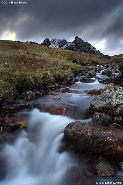
The Cobbler from the Allt a' Bhalachain

17th December 2013, The Cobble, Arrochar Alps

The Cobbler.  On OS maps it is also called Ben Arthur which is really the anglicised form of the gaelic ‘Beinn Artair’.  At 884m / 2900ft it falls short of Munro status by 100ft but what it lacks in height it makes up for in character.  It is one of the most impressive peaks in Scotland with three distinct and craggy summits which take on the shape of a cobbler at his last when seen from the A82 road above Arrochar at the head of Loch Long. A constructed path zig-zags up the hillside through an area of forestry, by-passing the original tramway route. Above the forest the path joins the old tramway path and continues from there, following the Allt a' Bhalachain to reach the Narnain Boulders. 


Technical Info:

Taken with a Canon EOS 5D mkII
Zeiss Distagon T* 21/2.8 ZE lens
EXIF: ISO-100 / 6 sec @ f/11 
Lee filters: 0.9 Hard GND
RAW File converted to TIFF in Canon DPP, developed in Adobe PSE9

Website  /  Profile
 

Tuesday, 31 December 2013

Flickr: 2013 in one frame

12 Photos, 12 months.  A snapshot of 2013
Selected from my Flickr photostream, one to represent each month in 2013.  Linked through to Flickr below.


January

February

March

April

May

June

July

August

September

October

November

December

Thanks for looking.  Please leave a comment below if you have time.

Sunday, 8 December 2013

Photo of the Month: November 2013

Burn of Sorrow
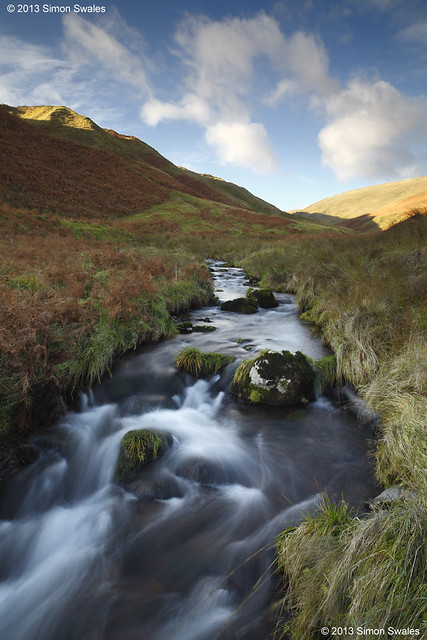
Burn of Sorrow, Ochil Hills

14th November 2013, Burn of Sorrow, Ochil Hills

Behind the historic town of Dollar, Clackmannanshire, lies picturesque Dollar Glen, a wooded gorge through which flows the Burn of Sorrow.  Footpaths, bridges and walkways lead through the glen becoming progressively steeper as they climb out of the gorge to converge at the impressive Castle Campbell, behind which are more paths which lead into the Ochil Hills.   Behind the castle lies the Glen Of Sorrow, a steep sided glacial trench through which the Burn of Sorrow flows from its source in the Maddy Moss.  This is sheep territory.  There are no paths but once in the glen the terrain is easy except for one narrow section avoided to the east.  The burn is delightful as it tumbles down the glen twisting and turning as it does.   You are unlikely to meet anyone once in the glen giving a sense of solitude more akin to The Highlands.


Technical Info:

Taken with a Canon EOS 5D mkII
Zeiss Distagon T* 21/2.8 ZE lens
EXIF: ISO-100 / 1.5 sec @ f/11
Lee filters: 0.6 Hard GND
RAW File converted to TIFF in Canon DPP, developed in Adobe PSE9

Sunday, 10 November 2013

Photo of the Month: October 2013

Lyon tracks
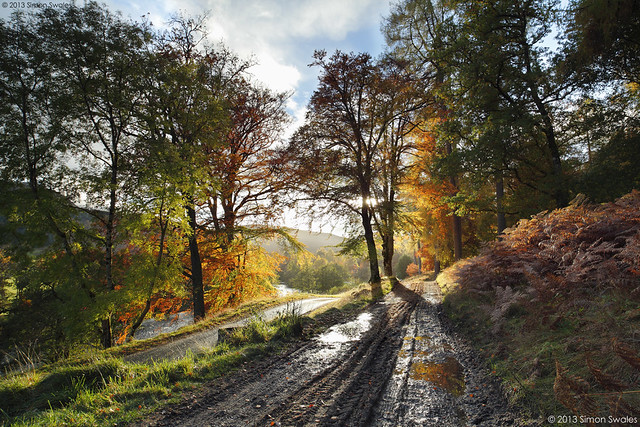
Glen Lyon, Perthshire

29th October 2013, Glen Lyon

Glen Lyon, at 34 miles, is the longest enclosed glen in Scotland. Sandwiched between Loch Rannoch and Loch Tay, it is remote with few settlements. In winter there is only one way in and out. At other times a single-track hill road can be used as an alternative from Loch Tay which climbs to over 500 metres before descending into Glen Lyon at Bridge of Balgie. It is a glen of contrasts. East of Bridge of Balgie it is very picturesque, especially in the Autumn for its colour.  West of Bridge of Balgie is more rugged hill country with a few farms and large hydro electricity schemes.


Technical Info:

Taken with a Canon EOS 5D mkII
Zeiss Distagon T* 21/2.8 ZE lens
EXIF: ISO-100 / 1/8 sec @ f/11, 1/4 sec @ f/11, 1/15 sec @ f/11, blended
Lee filters: 0.6 Soft GND
RAW File converted to TIFF in Canon DPP, developed in Adobe PSE9

Website  /  Profile
 

Thursday, 24 October 2013

Go Perthshire: The Hermitage, Dunkeld, Perthshire

The Hermitage is a National Trust for Scotland woodland situated on the banks of the River Braan along a section called the Falls of Braan where the river tumbles in a series of cataracts before its confluence with the River Tay.  It forms part of the larger Craigvinean Forest which is itself part of the Tay Forest ParkClick on the following link to download the comprehensive TFP Guide.


The footpaths around The Hermitage are linked to the trails of the Dunkeld & Birnam walks network, 36 miles of waymarked walking routes over a variety of terrain from flat paths to steep hillsides.  The Hermitage is right in the middle of this network.  It is signposted off the A9 where there is a large Pay and Display car park (free to NT & NTS members).  The path from the car park is wide and flat and suitable for wheelchair users which takes you, in little over 3/4 mile / 1 km, to The Hermitage.  Alternatively, two other FREE car parks can be used: Inver Brae Car Park to the south of Inver, just over the railway bridge, and there is also a small car park at Rumbling Bridge on the A822.  All car parks have large Information Boards to direct you to The Hermitage along the path network. 


In the autumn The Hermitage is a landscape photographers paradise when the yellows, oranges and reds of the deciduous trees contrast with the dark greens of the coniferous trees.  The Black Linn Falls at The Hermitage are spanned by a single arch stone bridge which makes a great viewing platform for the falls and also makes a fine composition itself from the banks of the river.  Note:  since 2011 the bridge does not provide access to the far side of the river as erosion has closed the path leading onto the bridge from that side.


From 11 am - 5 pm at weekends and in school holidays (not winter) the Big Tree Cafe in the main Hermitage car park serves home made soup, home baking, local dairy ice cream, tea, coffee, hot chocolate and cold drinks. 

Alternatively,  Dunkeld and Birnam cater extremely well for tourists and day-trippers with hotels, B&B's, pubs and cafes as well as a Co-Op supermarket (in Dunkeld). 

Satellite map of The Hermitage and Dunkeld area below.   


Sunday, 13 October 2013

Photo of the Month: September 2013

The Lost World
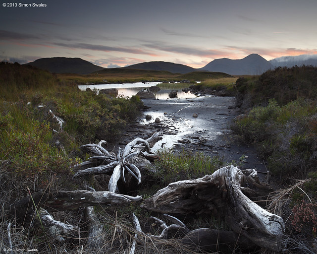
The Lost World, Rannoch Moor

29th September 2013, Rannoch Moor

By the time I reached Rannoch Moor [Mòinteach Raineach] the sun had set.  I parked just off the road near the bridge over the River Ba and headed west on foot following the river through peat hags.  When I found the exposed and bleached tree roots I knew I had to use them but the ground was moving like a sponge.  Even the slightest of vibrations would have ruined the shot so the 10-sec timer was used to allow sufficient time for me to reach terra firma and for the tripod to settle again. The River Ba is in the middle distance with The Black Mount [Am Monadh Dubh] behind.

Technical Info:

Taken with a Canon EOS 5D mkII
Zeiss Distagon T* 21/2.8 ZE lens
EXIF: ISO-100 / 4 sec / f/11
Lee filters: 0.6 Hard GND
RAW File converted to TIFF in Canon DPP, developed in Adobe PSE9