Pages

Showing posts with label Perthshire. Show all posts

Sunday, 5 July 2015

Photo of the Month: June 2015

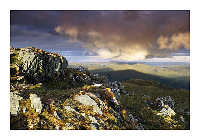
CAST A GIANT SHADOW
Cast a Giant Shadow

14th June 2015, summit of Beinn Ghlas, Perthshire

Ben Lawers, at 3984ft (1214m) and on the north side of Loch Tay, is the highest mountain in Britain outside the Nevis and Cairngorms ranges.  The mountain path starts from the car park at Ben Lawers National Nature Reserve and climbs over Beinn Ghlas, which, at 1103m is also one of the highest peaks in Britain. I reached Beinn Ghlas a little after 8pm to explore its summit with a view to photographing Ben Lawers at sunset (due soon after 10pm). Just before 9:30pm the sun appeared from the clouds far to the NW and strong backlighting has cast giant shadows of Ben Lawers (L) and Beinn Ghlas (R) onto the hillsides on the far side of Loch Tay.  The tops of the shadows are 8km away. The clouds were only partially in direct sunlight which added another element to the composition.
I completed the ridge walk to Ben Lawers after sunset before retracing my steps down to my car well after midnight. A headtorch was not required until I reached the NNR below Beinn Ghlas as there was still enough ambient light in the sky to walk along the mountain paths unaided.  


Technical Info:

Taken with a Fuji X-T1
Fujinon XF 18-135mm f/3.5-5.6 R LM OIS WR lens @ 18mm
EXIF: ISO-200 / 1/28 sec / f/8
Lee filters: 0.6 Hard GND
RAW File converted to TIFF in Fuji RAW Converter powered by Silkypix, developed in Adobe PSE9

Website  /  Profile

Sunday, 10 August 2014

Photo of the Month: July 2014

HEADS & TAILS
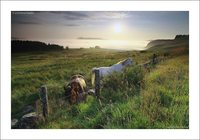
Heads and Tails, Cleish Hills


26th July 2014, Cleish Hills

Woke up at 4:15 a.m. as bright as a button.  Last nights weather forecaster had predicted that the eastern side of Scotland would be affected by a haar, or fog, which would roll in from the North Sea overnight. Looking out of the window there was no fog at all but I still got up and headed for the Cleish Hills.  It's a 20 minute drive on quiet roads, the final stretch being on the narrow hill road through Blairadam Forest. I glimpsed the fog just as I was coming out of the forest and my first reaction was to punch the air in triumph.  It was a sea of fog stretching to the horizon over much of the old county of Kinross-shire.  Poking through the fog were the hills around Loch Leven; Benarty and Bishop Hill with the dome of West Lomond behind.  With few clouds the red hues of the dawn sky subsided to blue once the suns disc had cut the horizon behind Bishop Hill.  The fog was still in shadow but eventually, as the sun rose higher, its light started to reflect off the fog which took on a yellow glow.  Just before 6 a.m. two horses appeared and came over to say hello.  Their profiles were caught by the light from the sun which was gaining strength rapidly as the minutes ticked by.  I was back home for 6:30am feeling elated.  Time for a brew before switching on the PC.


Technical Info:

Taken with a Canon EOS 5D mkII
Zeiss Distagon T* 21/2.8 ZE lens
EXIF: ISO-100 / 1/25 sec / f/11 
Lee filters: 0.9 Hard GND
RAW File converted to TIFF in Canon DPP, developed in Adobe PSE9

Website  /  Profile
 

Sunday, 13 July 2014

Photo of the Month: June 2014

Balvaird Castle - Commended: SLPOTY 2014 Awards
Balvaird Castle

6th June 2014, Balvaird Castle, Perthshire

Balvaird Castle is a late medieval tower house built around 1500 on the crest of a low hill in the eastern Ochil Hills.  Because of its strategic position it commands views in all directions.  It is under the guardianship of Historic Scotland. I've visited the castle on an evening a few times through the spring but the light has never been right for what I wanted.  Tonight was different though and what I found really striking was the spectrum of colour in the sky; from deep blues to the fiery reds, oranges and yellows of the setting sun far to the North-West. Today was also the 70th Anniversary of the D-Day landings on the beaches of Normandy and it was a fitting location to be 'at the going down of the sun'.


Technical Info:

Taken with a Canon EOS 5D mkII
Zeiss Distagon T* 21/2.8 ZE lens
EXIF: ISO-100 / 1 sec @ f/11 x 3 frames, stitched

Lee filters: 0.6 Hard GND
RAW File converted to TIFF in Canon DPP, developed in Adobe PSE9


Commended image - 'Landscape' category - SLPOTY 2014
 
Featured in Scottish Field Magazine - Scotland through a Lens - Mar 2015


Website  /  Profile


Sunday, 10 November 2013

Photo of the Month: October 2013

Lyon tracks
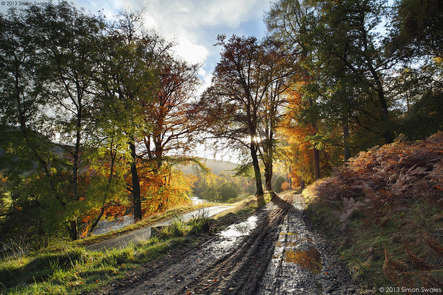
Glen Lyon, Perthshire

29th October 2013, Glen Lyon

Glen Lyon, at 34 miles, is the longest enclosed glen in Scotland. Sandwiched between Loch Rannoch and Loch Tay, it is remote with few settlements. In winter there is only one way in and out. At other times a single-track hill road can be used as an alternative from Loch Tay which climbs to over 500 metres before descending into Glen Lyon at Bridge of Balgie. It is a glen of contrasts. East of Bridge of Balgie it is very picturesque, especially in the Autumn for its colour.  West of Bridge of Balgie is more rugged hill country with a few farms and large hydro electricity schemes.


Technical Info:

Taken with a Canon EOS 5D mkII
Zeiss Distagon T* 21/2.8 ZE lens
EXIF: ISO-100 / 1/8 sec @ f/11, 1/4 sec @ f/11, 1/15 sec @ f/11, blended
Lee filters: 0.6 Soft GND
RAW File converted to TIFF in Canon DPP, developed in Adobe PSE9

Website  /  Profile
 

Thursday, 24 October 2013

Go Perthshire: The Hermitage, Dunkeld, Perthshire

The Hermitage is a National Trust for Scotland woodland situated on the banks of the River Braan along a section called the Falls of Braan where the river tumbles in a series of cataracts before its confluence with the River Tay.  It forms part of the larger Craigvinean Forest which is itself part of the Tay Forest Park.  Click on the following link to download the comprehensive TFP Guide.


The footpaths around The Hermitage are linked to the trails of the Dunkeld & Birnam walks network, 36 miles of waymarked walking routes over a variety of terrain from flat paths to steep hillsides.  The Hermitage is right in the middle of this network.  It is signposted off the A9 where there is a large Pay and Display car park (free to NT & NTS members).  The path from the car park is wide and flat and suitable for wheelchair users which takes you, in little over 3/4 mile / 1 km, to The Hermitage.  Alternatively, two other FREE car parks can be used: Inver Brae Car Park to the south of Inver, just over the railway bridge, and there is also a small car park at Rumbling Bridge on the A822.  All car parks have large Information Boards to direct you to The Hermitage along the path network. 


In the autumn The Hermitage is a landscape photographers paradise when the yellows, oranges and reds of the deciduous trees contrast with the dark greens of the coniferous trees.  The Black Linn Falls at The Hermitage are spanned by a single arch stone bridge which makes a great viewing platform for the falls and also makes a fine composition itself from the banks of the river.  Note:  since 2011 the bridge does not provide access to the far side of the river as erosion has closed the path leading onto the bridge from that side.


From 11 am - 5 pm at weekends and in school holidays (not winter) the Big Tree Cafe in the main Hermitage car park serves home made soup, home baking, local dairy ice cream, tea, coffee, hot chocolate and cold drinks. 

Alternatively,  Dunkeld and Birnam cater extremely well for tourists and day-trippers with hotels, B&B's, pubs and cafes as well as a Co-Op supermarket (in Dunkeld). 

Satellite map of The Hermitage and Dunkeld area below.   


Sunday, 8 September 2013

Photo of the Month: August 2013

Innominate
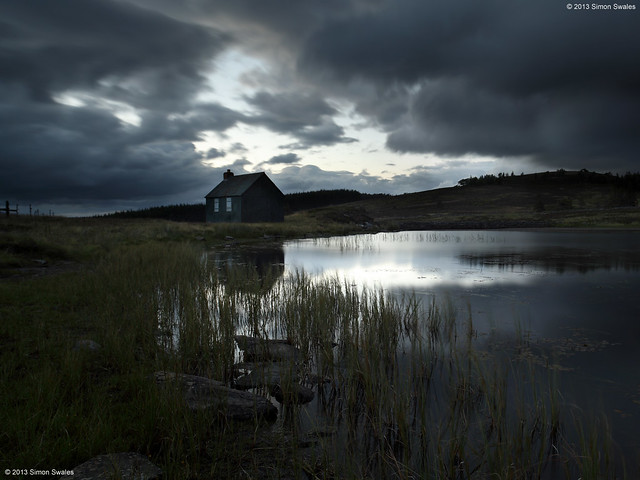
Innominate, Perthshire

2nd August 2013, Innominate, Perthshire

I like to wait around until well after sunset, especially in the summer months when the light lingers. Sometimes unexpected and magical things happen.  The sun had set 40 minutes prior to taking this image. A gap in the clouds allowed light to spill and be reflected on the surface of the innominate lochan high up on a hill road in Perthshire.  The painted corrugated iron hut has window shutters of bare metal. The gloaming light has created a Saturnine atmosphere. Innominate means 'un-named' and both lochan and hut are un-named on OS Maps.  I hope it stays this way.


Technical Info:

Taken with a Canon EOS 5D mkII
Zeiss Distagon T* 21/2.8 ZE lens
EXIF: ISO-100 / 25 sec / f/10
Lee filters: 0.6 Hard GND
RAW File converted to TIFF in Canon DPP, developed in Adobe PSE9


Editor's Choice - FifeWeather.co.uk "what I like is the fact that it's far removed from the 'picture postcard' type of landscape... it's dark, moody and quite foreboding - the small, forgotten, remote corners of the country under dark skies, where you almost feel like you're the only person left on the planet." Dec 2014


Friday, 12 July 2013

Go Ochils: Lower Glendevon Reservoir, Perthshire

I took a drive up into Glen Devon tonight to search out potential locations at both Upper and Lower Glendevon Reservoirs.  There is parking at the roadside where the private road signed for Frandy Farm leaves the main A823 road through Glen Devon.  Alternatively, drive 2km along the private road to Frandy Fishery (seasonal) and seek permission to park at the lodge. The track can be rough in places and livestock is allowed to roam freely.  From the fishery I made my way to where the road ends at Upper Glendevon Reservoir.  There wasn't really much potential here unless your forte is for concrete dams, walkways and overflow channels.  It was all a bit bleak.  


Returning to Frandy I noticed the outflow tower on the other side of the lower reservoir so once I was below Frandy Farm I pulled over and went for a look.  The evening was very warm, humid and quite still.  Ideal conditions for the scourge of every landscape photographer in Scotland; the midge, or little b*stards as they are mostly known by.  Once I reached the reservoir they descended on me, the camera, the lens and the filters.  I was fighting a losing battle.  At least I kept the fishermen amused with my constant blowing across the filters to stop the buggers from landing and waving my arms about like a mad man with a hood up and hat on.  The conditions were far from ideal too with the sun due to set too far to the north west for this location in July.  The outlet tower makes a good subject though with some interesting stone architecture and ironwork, although the final section of the bridge to the tower is out of bounds due to gates and locks, etc.  I will return in the autumn when the sun has moved around and the midges are no more.


A satellite map of Glen Devon and Glen Eagles is below.  Auchterarder is the nearest town, 5 miles to the north, and has B&B's, pubs, cafes, banks and shops.  For those burdened with heavy bags of money, fear not because The Gleneagles Hotel is there to help you lighten the load. 


Sunday, 7 April 2013

Photo of the Month: March 2013

Point of Impact
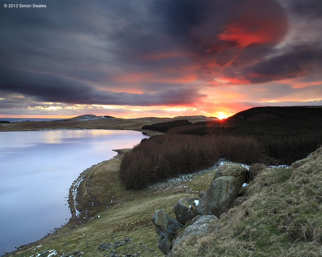
Point of Impact, Loch Glow, Cleish Hills


12th March 2013, above Loch Glow, Cleish Hills.

I've visited Loch Glow a few times over the winter months to study the lie of the land including a circuit of the loch itself.  It is approx. 2 miles / 3.2 km's around with the far side, Tipperton Moss, being a poorly drained marsh, making for extremely tough going.  The northern side is flanked by forestry and the craggy Cleish Hills which rise to over 350m /1150ft.  The Loch is a fishery run by Rosyth Angling Club and out of season there  are few visitors.  This evening I had the loch to myself. It was very windy and cold with sunset due at 6:10pm. The day had been overcast and the sky was dull and grey as I climbed the hill on the north side of the loch. After setting up my tripod and camera it was a case of waiting to see what, if anything, would happen. And happen, it did. Big bands of thick black cloud started moving in from the NW on strong winds.  The cloud was so black that even the weather forecasters on BBC Reporting Scotland mentioned it on the early evening broadcast.  The sun appeared, disappeared and then re-appeared as an intense orange ball as it set in the little dip in the hills. It lit up huge sections of black cloud with red light making one section of the sky look almost apocalyptic as if there had been an explosion.  Eventually the fiery sky subsided to dusky pinks and blues before settling down for the night but I had captured the moment perfectly which is why it is my photo of the month.

Technical Info:

Taken with a Canon EOS 5D mkII
Zeiss Distagon T* 21/2.8 ZE lens
EXIF: ISO-100 / 4 sec / f/13
RAW File converted to TIFF in Canon DPP, developed in Adobe PSE9

The changing sky at sunset