Pages

Tuesday, 31 December 2013

Flickr: 2013 in one frame

12 Photos, 12 months.  A snapshot of 2013
Selected from my Flickr photostream, one to represent each month in 2013.  Linked through to Flickr below.


January

February

March

April

May

June

July

August

September

October

November

December

Thanks for looking.  Please leave a comment below if you have time.

Sunday, 8 December 2013

Photo of the Month: November 2013

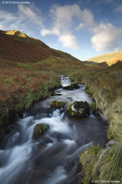
Burn of Sorrow
Burn of Sorrow, Ochil Hills

14th November 2013, Burn of Sorrow, Ochil Hills

Behind the historic town of Dollar, Clackmannanshire, lies picturesque Dollar Glen, a wooded gorge through which flows the Burn of Sorrow.  Footpaths, bridges and walkways lead through the glen becoming progressively steeper as they climb out of the gorge to converge at the impressive Castle Campbell, behind which are more paths which lead into the Ochil Hills.   Behind the castle lies the Glen Of Sorrow, a steep sided glacial trench through which the Burn of Sorrow flows from its source in the Maddy Moss.  This is sheep territory.  There are no paths but once in the glen the terrain is easy except for one narrow section avoided to the east.  The burn is delightful as it tumbles down the glen twisting and turning as it does.   You are unlikely to meet anyone once in the glen giving a sense of solitude more akin to The Highlands.


Technical Info:

Taken with a Canon EOS 5D mkII
Zeiss Distagon T* 21/2.8 ZE lens
EXIF: ISO-100 / 1.5 sec @ f/11
Lee filters: 0.6 Hard GND
RAW File converted to TIFF in Canon DPP, developed in Adobe PSE9

Sunday, 10 November 2013

Photo of the Month: October 2013

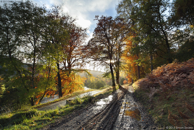
Lyon tracks
Glen Lyon, Perthshire

29th October 2013, Glen Lyon

Glen Lyon, at 34 miles, is the longest enclosed glen in Scotland. Sandwiched between Loch Rannoch and Loch Tay, it is remote with few settlements. In winter there is only one way in and out. At other times a single-track hill road can be used as an alternative from Loch Tay which climbs to over 500 metres before descending into Glen Lyon at Bridge of Balgie. It is a glen of contrasts. East of Bridge of Balgie it is very picturesque, especially in the Autumn for its colour.  West of Bridge of Balgie is more rugged hill country with a few farms and large hydro electricity schemes.


Technical Info:

Taken with a Canon EOS 5D mkII
Zeiss Distagon T* 21/2.8 ZE lens
EXIF: ISO-100 / 1/8 sec @ f/11, 1/4 sec @ f/11, 1/15 sec @ f/11, blended
Lee filters: 0.6 Soft GND
RAW File converted to TIFF in Canon DPP, developed in Adobe PSE9

Website  /  Profile
 

Thursday, 24 October 2013

Go Perthshire: The Hermitage, Dunkeld, Perthshire

The Hermitage is a National Trust for Scotland woodland situated on the banks of the River Braan along a section called the Falls of Braan where the river tumbles in a series of cataracts before its confluence with the River Tay.  It forms part of the larger Craigvinean Forest which is itself part of the Tay Forest ParkClick on the following link to download the comprehensive TFP Guide.


The footpaths around The Hermitage are linked to the trails of the Dunkeld & Birnam walks network, 36 miles of waymarked walking routes over a variety of terrain from flat paths to steep hillsides.  The Hermitage is right in the middle of this network.  It is signposted off the A9 where there is a large Pay and Display car park (free to NT & NTS members).  The path from the car park is wide and flat and suitable for wheelchair users which takes you, in little over 3/4 mile / 1 km, to The Hermitage.  Alternatively, two other FREE car parks can be used: Inver Brae Car Park to the south of Inver, just over the railway bridge, and there is also a small car park at Rumbling Bridge on the A822.  All car parks have large Information Boards to direct you to The Hermitage along the path network. 


In the autumn The Hermitage is a landscape photographers paradise when the yellows, oranges and reds of the deciduous trees contrast with the dark greens of the coniferous trees.  The Black Linn Falls at The Hermitage are spanned by a single arch stone bridge which makes a great viewing platform for the falls and also makes a fine composition itself from the banks of the river.  Note:  since 2011 the bridge does not provide access to the far side of the river as erosion has closed the path leading onto the bridge from that side.


From 11 am - 5 pm at weekends and in school holidays (not winter) the Big Tree Cafe in the main Hermitage car park serves home made soup, home baking, local dairy ice cream, tea, coffee, hot chocolate and cold drinks. 

Alternatively,  Dunkeld and Birnam cater extremely well for tourists and day-trippers with hotels, B&B's, pubs and cafes as well as a Co-Op supermarket (in Dunkeld). 

Satellite map of The Hermitage and Dunkeld area below.   


Sunday, 13 October 2013

Photo of the Month: September 2013

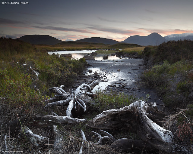
The Lost World
The Lost World, Rannoch Moor

29th September 2013, Rannoch Moor

By the time I reached Rannoch Moor [Mòinteach Raineach] the sun had set.  I parked just off the road near the bridge over the River Ba and headed west on foot following the river through peat hags.  When I found the exposed and bleached tree roots I knew I had to use them but the ground was moving like a sponge.  Even the slightest of vibrations would have ruined the shot so the 10-sec timer was used to allow sufficient time for me to reach terra firma and for the tripod to settle again. The River Ba is in the middle distance with The Black Mount [Am Monadh Dubh] behind.

Technical Info:

Taken with a Canon EOS 5D mkII
Zeiss Distagon T* 21/2.8 ZE lens
EXIF: ISO-100 / 4 sec / f/11
Lee filters: 0.6 Hard GND
RAW File converted to TIFF in Canon DPP, developed in Adobe PSE9


Sunday, 29 September 2013

Road trip: To Glen Etive and beyond

4:30 a.m. and the radio alarm sprung to life.  It was a bit of a shock but the previous evenings weather forecast had said that it was to be a clear night over the western Highlands followed by a sunny day so I had decided to get up early, drive, see the sunrise, do some exploring, maybe even climb a mountain and catch the sunset before heading home.  With the autumn equinox being little over a week ago, daylight lasts just under 12 hours.  I had packed a rucksack and camera gear the previous evening.
 
5:10 a.m. Reversed out of the drive, engaged 1st gear and headed for the Trossachs.  With sunrise due at 7:20 a.m. I had 2 hours to get to Rannoch Moor, 80 miles away. 
6:00 a.m.  Tesco Express opens in Callander.  I would usually stop, but not today.  Headed west through the Pass of Leny and then north beside Loch Lubnaig leaving the Trossachs behind.  The sky to the east was turning dark blue.  Next was Strathyre then Lochearnhead before the climb up through Glen Ogle.  The profile of the Tarmachan Ridge above Glen Lochay was visible by dawns early light on the decent into the forested Glen Dochart before heading west again for Crianlarich.  All the time the sky was coming out of night.
6:45 a.m. and I was through Crianlarich and 10 minutes later was past the Green Welly Stop in Tyndrum.  By now I could see the change in the sky as the colours of the sunrise approached so decided I had to stop somewhere or I would miss all the action.
7 a.m. Pulled over at the start of a forest road which gave a view down Gleann Ach'-innis Chailean with Beinn Dorain and Beinn a' Chaisteil flanking.  Got my camera set up on the roadside just as the fiery reds of the sunrise lit the sky above the mountains creating a dramatic scene.


7:15 a.m.  It was now daytime as I continued north crossing the bridge over the R. Tulla and onto Rannoch Moor stopping at the car park just after the big hairpin bend.  The rising sun was back-lighting the clouds that were hugging the rim of the Wall of Rannoch (a line of 3 Munros that mark its southern edge).


7:40 a.m. Another very short drive before stopping again north of Lochan na h'Achlaise.  The sun had risen high enough to spill its light over The Black Mount on the western edge of Rannoch Moor.


8:10 a.m. The sun was higher now as I continued north towards Glen Etive with Buachaille Etive Mor standing as if proud of its station at the head of Glen's Etive and Coe. Its summit was shrouded in cloud.  I turned onto the minor road into Glen Etive and on reaching the bridge over the River Etive decided it was still too busy with photographers eying up Buachaille Etive Mor so continued along the road before pulling over and heading down to the River Etive where I had the river bank to myself.


9:30 a.m.  Returned to the bridge over the River Etive where by now there were only a handful of people so I took up station to get the obligatory Buachaille Etive Mor shot which took an hour as I had to wait for the sun to reappear through some banks of cloud.

10:45 a.m. Re-joined the main A82 road and drove around Buachaille Etive Mor and down into Glen Coe which was mobbed with tourists.  All the car parks were overflowing as was the big lay-by at Alltnafeadh so I returned to Glen Etive, going right down the glen this time before parking up at a clearing near Invercharnan.
1:00 p.m. Brewed some coffee and chilled out for a couple of hours. 
3:00 p.m. Back to it with a short drive along to the 'Shed of Etive' which has a bicycle chained to the door.  The shed is deteriorating due to winter storms but the weathered wood, pitched roof and bicycle are very photogenic.  Eventually it might disappear completely to be replaced by something new.  I hope not.  It just needs a bit of TLC.  In a very rough and boggy clearing on the opposite side of the road to the shed was a very autumnal view back along the glen. 

4:00 p.m.  Started heading back up the glen towards Glen Coe.  On the way down I had seen some rowan trees on the far bank of the river near one of only two bridges I know about that cross the river.  Both are private.  The bridge near Coileitir can take 4WD vehicles and the other at Alltchaorunn has a gate across it that is usually padlocked.  But not today as I saw someone crossing it.  So I parked up and used the bridge to get to the rowan trees which were covered in berries.  

5:15 p.m.  Reached the A82 and turned west into Glen Coe.  Most of the day-trippers had gone.  Only a few cars were left and was able to park on the north side of the road below the Aonach Eagach.  The landscape on the south side of the glen is dominated by the highest and grandest mountain in Argyll, Bidean Nam Bian [peak of the mountains]  with its three imposing buttresses called The Three Sisters. It's one of the finest sights in The Highlands.  The sun was getting low casting shadows so climbed above the road to a vantage point higher up to admire the view.

 6:40 p.m.  It was now a race against time to return to Rannoch Moor for the sunset at 7 p.m.  I didn't quite make it and was kicking myself for spending too long in Glen Coe.  I didn't have to kick myself too hard though as I found a great location about 10 minutes walk from the car to photograph as the gloaming light was fading.   

7:30 p.m.  The sky was heading for complete darkness as I switched the car lights on and headed south, homeward bound, after a great day. 
________

With this area being a major tourist destination it is served well with cafes, hotels and pubs providing drinks, light snacks and main meals.  I usually stop at one or more of the following when I am in the area:
   
The Clachaig Inn, Glen Coe 
Kings House Hotel, Glencoe
Glencoe Mountain Resort & cafe, Glencoe     

Satellite map showing Rannoch Moor, Glen Etive and Glen Coe is given below


Sunday, 8 September 2013

Photo of the Month: August 2013

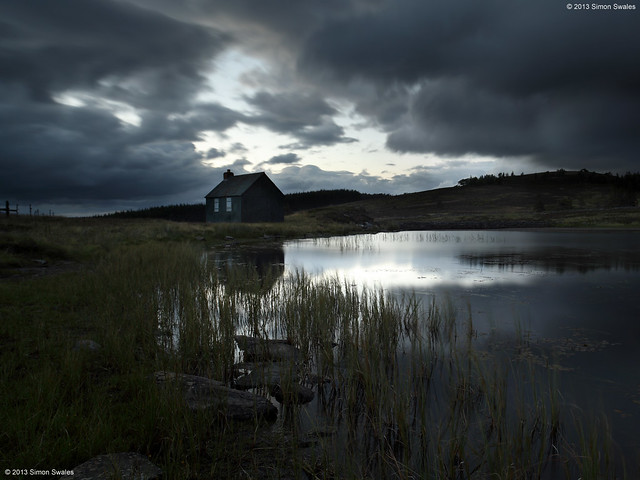
Innominate
Innominate, Perthshire

2nd August 2013, Innominate, Perthshire

I like to wait around until well after sunset, especially in the summer months when the light lingers. Sometimes unexpected and magical things happen.  The sun had set 40 minutes prior to taking this image. A gap in the clouds allowed light to spill and be reflected on the surface of the innominate lochan high up on a hill road in Perthshire.  The painted corrugated iron hut has window shutters of bare metal. The gloaming light has created a Saturnine atmosphere. Innominate means 'un-named' and both lochan and hut are un-named on OS Maps.  I hope it stays this way.


Technical Info:

Taken with a Canon EOS 5D mkII
Zeiss Distagon T* 21/2.8 ZE lens
EXIF: ISO-100 / 25 sec / f/10
Lee filters: 0.6 Hard GND
RAW File converted to TIFF in Canon DPP, developed in Adobe PSE9


Editor's Choice - FifeWeather.co.uk "what I like is the fact that it's far removed from the 'picture postcard' type of landscape... it's dark, moody and quite foreboding - the small, forgotten, remote corners of the country under dark skies, where you almost feel like you're the only person left on the planet." Dec 2014