Pages

Thursday, 15 August 2013

How I control Depth of Field in my landscape photography

For the overwhelming majority of landscape photographers knowing how to control Depth of Field is one of the fundamental requirements to improving our images.

The point where you a lens is focused is called the plane of critical focus and this will be the sharpest part of the picture. In front of and behind the plane of critical focus, the image becomes increasingly blurred, and the points at which it becomes unacceptably out of focus mark the limits of the depth of field.  So as a definition, Depth of Field (DoF) is the zone on either side of the plane of critical focus in which the image is acceptable sharp.

In Landscape photography, if I want the horizon line (which will be at infinity [∞] ) to be constantly in focus but also require as much DoF as possible so that objects in the foreground are also in focus then I focus the lens so that Infinity just lies at the farthest limit of the DoF.  When the lens is focused this way the point of critical focus is called the Hyperfocal Distance.  

The hyperfocal distance varies with the following:
  • Focal length of lens used.  The greater the focal length, the less DoF. 
  • Aperture.  DoF increases when a smaller aperture is used. 
  • Lighting.  Because sharp focus is very subjective there are certain lighting conditions which will give an apparent increase in the DoF like fog or low cloud/rain.
  • Distance between the lens and the nearest object within the scene that requires to be in focus.  The greater the distance the easier it is to control DoF.
  • The size of the sensor in the camera.  As far as DoF is concerned, generally speaking, the smaller the sensor the greater the depth of field.
For now it is safe to say that the maths involved in working out hyperfocal distances has been done by "Top Men", which has made it easy for me to produce my own hyperfocal distance charts which I laminate and keep in my bag for referring to when on location.  

Below are copies for cameras with Full Frame sensors, Canon's APS-C sized sensors and Nikon's DX-Format sensors covering the most popular focal lengths for landscape photographers in their chosen format.   Click to view each table at a larger size.


For those who would like to download a PDF version of each chart please click on the appropriate link below.  Once downloaded the charts can be read by a .pdf file reader or loaded into Photoshop for conversion to another format.  Once printed the table(s) can be cut out and laminated (it will be a handy A6 size) for keeping in your bag.  Full instructions are given on each table.

DoF Guide for Full Frame Sensors.  f/2.8 to f/5.6                   DOWNLOAD

DoF Guide for Full Frame Sensors.  f/8 to f/16                       DOWNLOAD

DoF Guide for 1.6x Crop Frame Sensors.  f/2.8 to f/5.6          DOWNLOAD

DoF Guide for 1.6x Crop Frame Sensors.  f/8 to f/16              DOWNLOAD

DoF Guide for 1.5x Crop Frame Sensors.  f/2.8 to f/5.6          DOWNLOAD

DoF Guide for 1.5x Crop Frame Sensors.  f/8 to f/16              DOWNLOAD
Sunday, 11 August 2013

Photo of the Month: July 2013

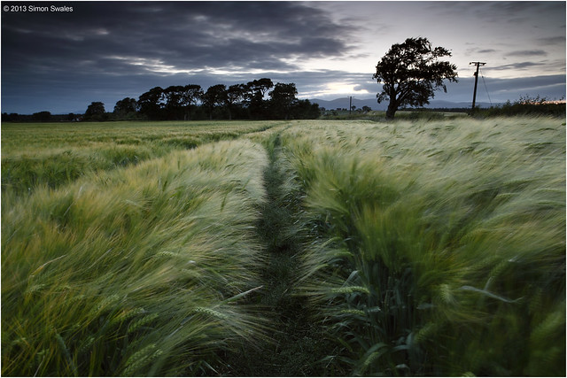
Telegraph Road
Telegraph Road, Culross, Fife


1st July 2013, Gallows Loan, above Culross
 
I have been visiting this field above Culross since the Spring when the crop was merely a few inches high.  Each visit sees new growth and a change in colour.  My last visit was 3-weeks ago.  Now it is thigh deep, the sun has ripened the ears and I expect it will soon be harvested.  With the sun setting at about 10pm there is luminosity in the sky for a long time afterwards.  I took this image 25 minutes after sunset in the gloaming light.  The trees were all silhouettes against the sky whilst the tram lines in the crop helped create a sense of depth with their dark shadows.     

Technical Info:

Taken with a Canon EOS 5D mkII
Zeiss Distagon T* 21/2.8 ZE lens
EXIF: ISO-100 / 13 sec / f/16
Lee filters: 0.9 Hard GND
RAW File converted to TIFF in Canon DPP, developed in Adobe PSE9


Friday, 12 July 2013

Go Ochils: Lower Glendevon Reservoir, Perthshire

I took a drive up into Glen Devon tonight to search out potential locations at both Upper and Lower Glendevon Reservoirs.  There is parking at the roadside where the private road signed for Frandy Farm leaves the main A823 road through Glen Devon.  Alternatively, drive 2km along the private road to Frandy Fishery (seasonal) and seek permission to park at the lodge. The track can be rough in places and livestock is allowed to roam freely.  From the fishery I made my way to where the road ends at Upper Glendevon Reservoir.  There wasn't really much potential here unless your forte is for concrete dams, walkways and overflow channels.  It was all a bit bleak.  


Returning to Frandy I noticed the outflow tower on the other side of the lower reservoir so once I was below Frandy Farm I pulled over and went for a look.  The evening was very warm, humid and quite still.  Ideal conditions for the scourge of every landscape photographer in Scotland; the midge, or little b*stards as they are mostly known by.  Once I reached the reservoir they descended on me, the camera, the lens and the filters.  I was fighting a losing battle.  At least I kept the fishermen amused with my constant blowing across the filters to stop the buggers from landing and waving my arms about like a mad man with a hood up and hat on.  The conditions were far from ideal too with the sun due to set too far to the north west for this location in July.  The outlet tower makes a good subject though with some interesting stone architecture and ironwork, although the final section of the bridge to the tower is out of bounds due to gates and locks, etc.  I will return in the autumn when the sun has moved around and the midges are no more.


A satellite map of Glen Devon and Glen Eagles is below.  Auchterarder is the nearest town, 5 miles to the north, and has B&B's, pubs, cafes, banks and shops.  For those burdened with heavy bags of money, fear not because The Gleneagles Hotel is there to help you lighten the load. 


Sunday, 7 July 2013

Photo of the Month: June 2013

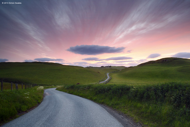
The long and winding road
The long and winding road, Ochil Hills
 
28th June 2013, Above Path of Condie, Ochil Hills

The hill country west of the M90 motorway and east of the A823 through Glen Devon.   Geographically part of the Ochil Hills and encompassing the old boundary between Kinross-shire and Perthshire, this is a lonely area off the beaten track.  Just hills, farms, forestry and winding roads.  From the centre of Milnathort a road heads north, over the M90 motorway towards Glenfarg.  After 2 1/2 miles a sign read 'Path of Condie'  4 1/2 miles so I turned left to see where it would lead. 1 1/2 miles further along the road snaked and dipped between two rolling hills so I pulled off the road to have a closer look.  As sunset approached the sky was still blue with thin, wispy clouds radiating outwards from where the sun would be setting, which, one week after the summer solstice, would be in the north west around 10 o'clock.  Even after the sun finally set the luminosity in the sky lingered and the pink hues of the gloaming light were absolutely astonishing.  


Technical Info:

Taken with a Canon EOS 5D mkII
Zeiss Distagon T* 21/2.8 ZE lens
EXIF: ISO-125 / 5 sec / f/16
Lee filters: 0.6 Hard GND
RAW File converted to TIFF in Canon DPP, developed in Adobe PSE9


Tuesday, 18 June 2013

Go local: Fields at Crombie, Fife


The field is a few minutes’ drive from my home in Cairneyhill.  Not only is it planted with wheat, which provides the foreground interest, but it’s advantage over other local fields is that it’s on a small hill and gives views across to the north-west where the sun sets at this time of the year.  It’s a place I can get to if the sky suddenly develops some colour around sunset. A lay-by at the entrance to the field provided easy parking.  The channels created by the tractors make natural lead-in lines and break up the continuous swathes of green whilst adding shadow areas too.  Tonight I left the house at 9:35pm, got parked up at 9:40pm, was set up in the field by 9:50pm, spent 30 mins photographing the sunset and gloaming light following sunset and was back home for 10:35pm.  Pretty good mini-session I'd say. 


Sunday, 9 June 2013

Photo of the Month: May 2013

..Пп........
After sunset, Elie Ness Lighthouse, East Neuk


6th May 2013, Elie Ness Lighthouse, East Neuk 

After a day in St Andrews, supper at The Fish Inn, Elie, and a very short drive to Ruby Bay I made my way around to the lighthouse and waited for sunset.  Sunset proved to be better further along the coast but in the blue hour the lamps of Elie Ness lighthouse were lit and Ruby Bay reflects the last of the sunset colour. On a Spring high tide Elie Ness can become a very temporary island, hence the bridge which takes the path across a very narrow inlet.  


Technical Info:

Taken with a Canon EOS 5D mkII
Zeiss Distagon T* 21/2.8 ZE lens
EXIF: ISO-125 / 20 sec / f/11
Lee filters: 0.6 Soft GND
RAW File converted to TIFF in Canon DPP, developed in Adobe PSE9


Sunday, 12 May 2013

Photo of the Month: April 2013

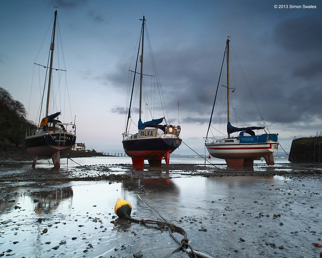
Buoy racers
Buoy Racers, Aberdour Boat Club, Fife

30th April 2013, Aberdour Boat Club, Fife. 

The tide was retreating rapidly when I arrived.  Being a Spring low-tide it more or less drained the harbour of water as I wandered amongst the small craft.  The tidal range is quite significant.  I was quite a distance from the rear of the harbour when I took this, with the majority of small craft being behind me.  I waited for the sun to set, for the sky to 'cool' down and used the reflections off the stony harbour basin to create a very contrasty scene with deep hues and dark shadows.  The yellow buoy and the snaking cable lead the eye perfectly.  


Technical Info:

Taken with a Canon EOS 5D mkII
Zeiss Distagon T* 21/2.8 ZE lens
EXIF: ISO-100 / 3 sec / f/13
Lee filters: 0.6 Soft GND
RAW File converted to TIFF in Canon DPP, developed in Adobe PSE9